Florida Coast to Coast 2008
It was a small crowd of racers that would be facing what is now by far the most challenging race in Florida – the coast to coast. I would be racing with my Primal Quest partner – Julie Ardoin, and two of her friends – Clay Abney and Joshua Trivet. The pre-race and preparation were the usual – though we did not get our maps until 8 and did not get a chance to start plotting (40 UTM points) the first half of the course (all we had maps for) until 9 PM which as always makes it a long night. We finally got to sleep around midnight which would give us a good 5 hours of sleep before we headed out the next morning at 6 AM.
The race started with a prayer and then a 4 ½ mile beach run followed by a roughly 18 mile paddle across the Banana River, north up Sykes Creek, west down the 528 barge canal and then south to Hubert Humphrey Park on SR 520. The weather was cool and slightly overcast making for very pleasant paddling. The last 4 mile section was quite exciting for Julie and I as we were paddling in a Pamlico 160 with an open cockpit. Their was a strong headwind and the waves were cresting the boat. Our paddling experience helped keep us upright, but we did have to essentially paddle sprint the 4 mile section to keep the boat in solid control. Josh and Clay, paddling an Amaruk had a difficult time keeping up.
The transition was to bikes at this point and our crew, made up of Heather, Oscar, and Abhijit showed us how a good crew can help keep you moving. Their were a few teams in front of us – but I was not concerned, this was way too early in a long race to worry about field placement. Our objective was to keep a strong pace for this bike leg which started with an easy, but long bike ride straight west on SR 520 to the southern entrance to Tossohatchee near SR 528 – about 34 km. The cooler weather we had on the paddle gave way to sun and heat and it was starting to get to Joshua. We stopped once to eat and cool him down. We were staying close with Troy Couture – one of the brave solo racers to attempt this challenging race.
The next leg of the race though Tosohatchee would be a much tougher experience for most teams than it looked. The navigation held some challenges, but the heat held more. This is where we started with problems. The heat was putting Joshua into heat exhaustion and Clay was suffering from a knee injury. We were finding it very difficult to keep the group moving. At one point Clay was curled up in fetal position, looking really pale. He told Julie that he might pass out. Julie deadpanned – “If you pass out we’ll stop – now get your bike and let’s go”. Josh meanwhile was showing early signs of heat exhaustion with serious muscle cramps and alien looking spasms in his leg muscles. We used combinations of walking, resting, coaxing, double biking, and pack carries to make it through this section and finally emerged at the other end of Tosohatchee a pretty bruised up team. The good news is that the remaining bike leg was a 26 km road ride. I had brought my tow rope so was able to tow Joshua to the TA and Clay had recovered enough that he was able to maintain pace. It was not necessarily a fast road ride, but it was good enough to get us there. At the TA it was pretty obvious that our 4 person team was about to become a 2 person team. Josh had full-blown heat exhaustion and Clay was pretty much in and out of pain. The only team ahead of us at the time was Nature Calls and there were a few other teams in the TA that looked like they had been sent straight to the TA. My family was here which gave me a great mental and psychological boost. We decided that Julie and I would continue on, we also started calling ourselves Team Blue (our Primal Quest team name).
The next leg of the race would be a long trek across the Econlockhatchee State Forest. We would be picking up 5 checkpoints along the route. Julie and I decided that we would try to catch up with Nature Calls in this segment, who had a 30 minute lead out of the TA. It was starting to get cooler and we figured we could make it to the next TA (at Adventure Cycles) between 9 and 10 PM meaning we would be able to use the night to run better. Though many of the teams would hit this section in the dark, we hit all the points within the forest in the daylight and found them relatively easily. It did not hurt that I had a high level of familiarity with the area. Both checkpoint LBE2 and LBE3 had multiple flags hanging – it appeared that other groups were using the same locations (which made sense as the flags were hung in distinct or scenic locations and others would have noticed this). It was starting to get dark as we exited the forest at LBE5 and headed for the first numbered race checkpoint CP1. The final portion of the trek was through downtown Oviedo and on the paved Cross Seminole trail. CP2 gave us some difficulty in the dark, but some pace counting got us to it. We caught up with Nature Call’s who we could see resting and eating at an intersection up the road, but they continued on before we found CP2. As we left the CP we could see lightning and hear thunder in the distance. As we continued it got closer and we started back into our slow run. The rain started and then we had a large crack-boom of lightning. We were about a mile from the TA when it really started raining hard and lightning was all around us. There was nowhere to shelter so we simple ran harder to the TA where the teams were hanging out under the eaves of our local bike shop – Adventure Cycles.
Our crew had cooked spaghetti and we decided we would take our time in the TA and eat and rest. It was still too dangerous to head out into the storm. My family was once again here providing mental support. The next leg of the race would be essentially a night bike ride across the city on back roads with a could of checkpoints and a stop at Travel Country Outdoors. One of the checkpoints turned out to be more challenging than it should. I decided to take the eastern-most entrance into the Bear Creek nature trails because the clue for the control there said to. This entrance was not from the parking area where there were two trail entrances. The clue had intended for us to take the easternmost trail from the parking lot, not another trail further from the side of the road. After about 15-20 minutes we figured it out and were ready to bike on. Julie had gotten a kick out of the entire thing. I figured I would try to make up some of this time by biking hard. It was cool (and wet) out – but the conditions would be good for biking as there was no risk of overheating.
We arrived at TA5 wet, happy, and a little exhilarated by the night ride. We were about 15 minutes behind Nature Call’s. The crew had good food at this TA also and we knew that we would need some serious food for this next leg of the race. It looked like a relatively short (30 km/18 mile) trek that would take about 4 hours. This did not, however take into account the terrain and difficulty of the controls. The first control point was due north of the “Bridge to Nowhere” in the Wekiva swamp. The bridge was an old massive concrete bridge that was probably built when people though wetland were only for filling and destroying. Now the bridge led into the swamp. We kept a due north bearing and simply go lucky coming right onto SP1 – the first checkpoint in this section. From this point we simply needed to bushwhack 2 km north through the swamp to a tram road to find SP2. This is where the going got tough.
For anyone who has never bushwhacked their way through a thick swamp in the dark, you have no frame of reference and cannot possibly understand what thing is like. Issue #1 – spiders and bugs. Swamps are full of them and they want nothing more than to sting or bite you. Every step entailed knocking down a few webs. Issue #2 – the terrain. This involved endless climbing over fallen trees, bashing through palmettos, crawling over and under trees, and fighting sticker bushes. Issue #3 – Direction. Without constantly checking the compass it is easy to simply do circles. It really does all look alike and it is very easy to get confused. It took us nearly 3 hours to cross the swamp. When we exited we came out on what used to be a logging trail marked on the map. The trail had been replanted with pine trees and was not really a trail – but it was obvious that it had one time been a logging road. Of course planted pine always comes with thorny vines – usually raspberries, and this was no different.
After 3 hours of swamp bashing we were just happy to be on a road. So happy in fact that we spent a couple of hours going up and down it looking for SP2, which was placed on the wrong intersection (east of the mapped one). Of course we did not go too far east looking – we checked too far west. We did go to the location where the control was mapped and I even took our GPS tracker and pointed it to the sky so I could prove we were in the right spot. Nature Call’s had found it which was impressive. After we gave up and headed north again we had no problems with the other controls – though they were definitely more challenging than the controls on the first trek. The SP7 was especially challenging – on an earth bank that was hard to get to – being surrounded by thick vines. Julie and I circled around it – and I finally found a spot to get to it. As I came out I heard Jim from team NC. I gave him directions to SP7 and then Julie and I headed out to the Horse Barn that had restrooms with running water. After a little sink shower to get the worst of the swamp mud off and also scrub with soap the bites that were all over my wrists and legs I felt much better and we headed to TA6 – Katie’s Landing.
At this point we learned that all the other teams (other than NC and ourselves) had been bypassed around this section. Some of the teams were really suffering – but the good news was our two downed members were feeling much better. There were plenty of teams that had already headed out on the paddle. Jamie (one of my regular team partners – who had done this race with me multiple times) and her family were here for support. It was a great chance for them to meet Julie – as they would be supporting us in a few weeks at Primal Quest.
Julie and I had been looking forward to a nice paddle down the Wekiva and St. Johns River heading to Blue Springs State Park. This turned out to be a pretty paddle, with lots of wildlife. Julie was even able to get a short nap in the Necky Amaruk. The only down side of this leg was the large number of big boats zooming up and down the St. Johns River. At Blue Springs we would get the maps and instructions for the second half of the course. We did not know where we were going – but we were feeling very strong after a solid 30 hours of racing and were ready to take on Coast to Coast Part II.
Monday, May 26, 2008
Wednesday, May 21, 2008
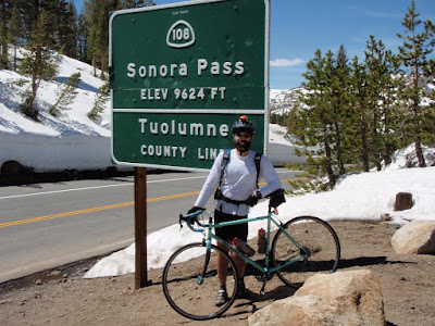
Sonora Pass
Last weekend I went for a 50 mile ride over Sonora Pass and back. This photo says it all:
I put up all my photos on Picasa, I'll add a few captions to describe them. The ride I did is also described fairly well by this other web site. They also turned around at the Marine base, they must have felt the same despair at the sight of the rest of the downhill to US 395 that I did.
I put up all my photos on Picasa, I'll add a few captions to describe them. The ride I did is also described fairly well by this other web site. They also turned around at the Marine base, they must have felt the same despair at the sight of the rest of the downhill to US 395 that I did.
Cement Creek Road

This is a steep trail. You can just make out the red Honda on the road. You may have to "click" on the picture.

Monday, May 12, 2008
Hammerfest
I got a chance to compete in an off-road bike race this weekend, though I took second in 2:21, just behind Team Primal in 2:19. It was an awesome race and a cool format - it is at http://eaglinar.blogspot.com/
Sunday, May 11, 2008
Pimped My Bike
So I've been down for almost a week now with (what started as) a viral stomach flu thing. Since I have not been training I've had a chance to spend some quality time with my loved ones. Yes, I worked on my bikes.
Here is a breakdown of the work I did on my PQ racer - a Santa Cruz Superlight.
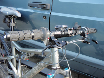
First off I ditched the crappy SRAM stock grip-shift grips and replaced them with clamp-on ones. I like this kind because they have a larger circumference that makes them more comfortable on long rides. I also replaced the "cheap" Speed-Dial SL levers with some Speed-Dial Ultimate ones I had on an old bike. Not sure if I saved any weight on this, but the result is much more functional.
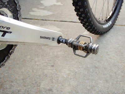
Out with Egg-beater SLs and in with Egg-beater 2-Ti. These are a nicely worn black color.
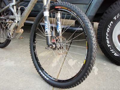
I put some new tires on and I swapped the wheels from my hardtail. Look the same? Nope - the spokes on this set are titanium.
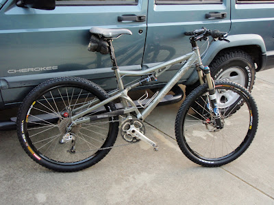
The finished product.
Here is a breakdown of the work I did on my PQ racer - a Santa Cruz Superlight.
First off I ditched the crappy SRAM stock grip-shift grips and replaced them with clamp-on ones. I like this kind because they have a larger circumference that makes them more comfortable on long rides. I also replaced the "cheap" Speed-Dial SL levers with some Speed-Dial Ultimate ones I had on an old bike. Not sure if I saved any weight on this, but the result is much more functional.
Out with Egg-beater SLs and in with Egg-beater 2-Ti. These are a nicely worn black color.
I put some new tires on and I swapped the wheels from my hardtail. Look the same? Nope - the spokes on this set are titanium.
The finished product.
Monday, May 5, 2008
San Luis Hell Paddle
Robert from Kayak Lake Mead suggested practicing paddling in the wind for the upcoming Desert Winds race. So I took my kayak out to the local big, windy reservoir - San Luis Reservoir. There have been adventure races here in the past, including the first 24hr race I ever did.
Today there was just a small-craft wind advisory. There are red beacons around the lake that start flashing when the wind is really nasty. They were already on when I showed up. A park ranger warned me to be careful out there. It was likely gusting to 40mph around some of the points.
I paddled out to the long inlet on the south side of the lake. It was calm there, at least. I practiced some wet exit and entry just in case I would need that skill in the race. The water was still pretty cold but I had a wetsuit on.
On the return trip I fought the very nasty headwind. It slowed me down to below 2mph at times while I was paddling all-out. Very exhausting. Although I managed to stay in my boat I was glad I had the wetsuit on. If I fell out I would probably be blown across the lake before I would be able to get back in. It took me 1:20 to go "out" and 2:40 to go nearly the same distance "back".
Forgetmenot Ridge
Last Friday I took the afternoon off to go hicking. It was a spectacular day with a bright sunshine and warm (~70) weather.
The last ~15km of the road to the base of the Forgetmenot ridge is closed in winter so I biked in from the gate. Since most of it is uphill and because I managed to convince myself that bushwaking with my bike on the shoulder would be (yeah right) faster than riding the last 3 km, it still took me nearly an hour to reach the trailhead. I was more cleaver on the way back and avoided such useless mean of travel.
The rise to the ridge starts with a steep climb that gradually levels off to a nicer angle. 700m of climbing later, you reach the top of a flat wide ridge that extends for about 6 km. Along the ridge, there are sevel false peaks. There was even a little section that forced me to do a little bit of rock climbing. I named this section the mini Hillary Step! (see picture)
I went to the end of the ridge and back tracked to the start. As I said, I elected to bike around for an extra 3km instead of bushwaking this time around! All in, I was away from the car for 7 hrs, went up by 1155m and drank 13 scoops of perpetuem and a ate few bars. I still had to stop at Wendy's on the way home and it tasted sooooo good. I guess Ron and I will fight for Julie's fast food during the race!
Sorry about the small pictures, I took them with my cellphone because I forgot the camera...
View of the flat wide ridge (2300m elevation)

Hillary Step: Atthe top of this little peak, I could either traverse it on the left in 4-5 feet of snow(not!). to the right on a scree field with a strong side slope or go straight up and climg the last 10 feet to get over it. That's what I did and it was certainly the easiest way to do it.

Subscribe to:
Posts (Atom)