Monday, January 28, 2008

Spillway Training


On Friday I went to the Spillway with my teammates that will be doing the Swamp Stomp. We were able to get 5 or 6 hours of paddling and trekking done in the cold and rain. The conditions presented a great opportunity to test our gear choices. I liked the Seal Skin gloves for paddling and I used polar fleece gloves for the trek and pulled latex gloves on top of the fleece. Instant water-proofing and it seemed to hold the warmth rather well. I will have a better chance to try this combo out when we go to Oak Mountain next weekend. This is a picture of my kayak on top of my bicycle accessory.

Sunday, January 27, 2008

Ohlone Trail, Part 2

My knee was feeling ok so I decided to take on part 2 of the Ohlone Trail on Saturday. This section runs from Sunol Wilderness to Rose Peak. I brought my trekking poles and kept the intensity way down. Still, it was 6000ft of climbing and 18.5 miles.

The weather was pleasant for a change. Cloudy the whole time but much warmer and no rain (yay!). Many good views and the trails were in great condition.

Although I had planned an out-and-back, after the "out" part I decided to explore some alternate routes for the return trip. Very little of the return trip was spent on the main trail. The rest was a combination of seldom used trails, cross country, and, uh, some private property.

I did get some pitures.


On the way out I spied Goat Rock, which I decided to scramble up on the return trip.


From Rose Peak I had nice views back towards the bay to the city and Mount Tam in the distance.


On the return trip I headed down to the base of Goat Rock, which looks much larger from below. It was an easy walk up the back side. I tried to find a way down the rocky face, but couldn't find anything that looked safe. From the rock I headed cross-country out to the main road and the jogged back to the car.


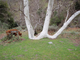
I stopped at the bottom of the W-Tree Rock Scramble to take a picture of its namesake tree.

Sunday, January 20, 2008

Big Coast Loop

One of my knees told me to skip going for a big run this weekend. I suspect IT band syndrome caused by cranking up my weekday mileage and intensity. It's nothing bad (yet), just being careful. As soon as I noticed it I cut back my running miles to be safe. Biking doesn't hurt at all.

So instead of going out to run the second section of the Ohlone trail I went for a monster road ride instead. Some people call this ride the "Big Coast Loop." It takes you over the Santa Cruz mountains, along the coast for a bit and then back over. From where I live it was 78 miles with 7800 feet of climbing.

Once again I tried to remain focused on my HR (130-140) and cadence (over 80 rpm, if possible). On the flats I find myself putting much more effort into it to keep my HR up, but the hills really slow me down. On this ride I was 30 minutes slower than I have been in the past. I don't want to trash my body, and I don't think reducing the intensity on a ride this long costs me any more than time.

No pictures (yet) - I am in techno-hell right now. I bought a new camera (Olympus Stylus 790 SW) thinking that a waterproof and shockproof camera would be good for me. However, it is utterly incompatible with my home computer that runs Ubuntu 6.06. I was spoiled by my previous camera (a $99 Canon model) that worked flawlessly. I did manage to get the images off my camera to another laptop I own (freebie from work running Vista), but I can't edit them successfully using gThumb on my main machine either.

Sunday, January 13, 2008

BAOC Tilden Park Meet

Not much to report for me this weekend. I went to the Bay Area Orienteering Club meet at Tilden park near Oakland. Kinda disappointing. I had planned to do the blue and long-orange courses but I started late and did poorly on the blue course. I missed the last start time for the long-orange by a few minutes.

It was the first time I have done a blue course and it showed. The northern half of the course was probably 90% dark green (impenetrable brush) on the map. Finding your way through it was all about choosing the right route. After the first couple of points I was doing OK, but it was too late.

That was a weak end to a slightly disappointing week of training as well. Cathy and Ellie had to stop running with me because Cathy hurt her ankle. I also missed my Thursday ride due to rain (I really should have gone). Good weather is in the forecast ahead so hopefully I can get all my workouts in.

I've decided against going to the San Diego O-meet next week because of time concerns. It's a really big drive or a fly plus rental car thing. So I'll probably go out for a big long run instead.

Prairie Link Mountain Loop... or so I though

The plan was simple: Park the car, take the trail straight up 2300' to the mountain top, look at the gully and if looked feasible, bushwhack the gully down to the dirt road, run back to the car. This should take about 3 hours.....

Yesterday was a a gorgeous day here: temperature around freezing, no wind and clear, clear sky. So I drove out to the foothills, a 45 minute drive from my house. The nice thing about the foothills is that since they sit a few mountain ranges on the East side of the continental divide, they don't get much snow. The climate there is very dry (as it is in Calgary) with humidity level almost never above 30%

So I started my "loop" by climbing 2300' on a very slippery trail. When I got to the top, the view were magnificent. See picture below and little video.


Here is the little video (I tried to keep it small). It starts looking at the prairies looking East and turns counterclockwise.


Then I put the second phase of my "plan" to execution. I scoped the gully to see if I though I could safely go down there by myself. Getting to the dirt road was only about 2-3 miles. It started with a scree field that was pretty steep but certainly manageable and then everything funneled into a creek (that is now dry and/or frozen anyways). the snow did not look too deep, even on the creek bed. Take a look:


I decided that the gully was both safe and manageable. So down I went. Everything went as expected, the scree was steep and very slippery and the snow at the bottom was only a foot or two deep.

I slowly made it down to the bottom, but then, this is where the plan "failed". With only 200 yards to go and the road in sight, I faced a 30' high cliff. In the spring, this should be a very nice waterfall. I obviously could not jump it. I looked around, and the 30' cliff rose to 100' and 200' cliffs on both side of the creek bed.. Cliffed-out at 200 yards from the road!

I looked around a little, but quickly figured out that the only way out of there was to backtrack all the way up the hill, which I did.

Back at the top, I enjoyed the scenery for a few more minutes and headed back down to the car.

So this is how a 3 hr "loop" turned out to a 4-hour Out-and-back. I hate out-and-backs, but sometimes, I guess this is the only way.

Statistically: the hike took 4:15 hrs and had 4300' of elevation gain.


Sunday, January 6, 2008

Sunol Wilderness

After the Big Storm rolled through I went for a run on Saturday at a place called Sunol Regional Wilderness. The storm wasn't really over and overall the experience was a little unpleasant. The temps were in the 40s and the rain came back part way into my run. Good training for the upcoming BAAR BRAWL race, which always has weather like this.

Got a track on MB, but my GPS equipment didn't properly log some of it. Usually in spots where I was climbing or descending very steep slopes. This run was not too long but was all about the hills. I did about 6000ft of climbing on very steep slopes. Much of the run was off-trail.


Probably the nicest part was the Maguire Peaks, shown here. My route took my up one of the steep ridges on the left, across the three peaks and down the ridge below the third peak.


The wind and rain came in just as I was reaching the summit of the first peak. I had to lean into the wind to avoid being blown off the hill. I snapped a picture facing north to the reservoir below from the safety of a few bushes.


You can see how steep the cliffs below the peaks are here. The climb down them is not difficult, but there are a few places you have to scramble with hands and feet. The rain really started to come down after this and I didn't get any more decent pictures. The peaks aren't the highest place in the park, I went to that place next.

Towards the end of the run I had planned to follow a path down a rocky creek bed called the "W-Tree Rock Scramble". However with the rain coming down hard I didn't think it would be very safe. I had no desire to encounter the force that chucks boulders down this creek. Instead I bombed down a ridge parallel to the creek to the Ohlone trail which crosses it. When I did cross the creek it was pretty high. At best the scramble would have been unpleasant.

After that it was a simple run on trails and roads out.

BCS Fever

 
Posted by Picasa


Today was all about 60 miles in the saddle which is never boring when it includes tours through some of New Orleans historic neighborhoods. The day was full of entertainment as the city has gone completely nuts with football fever. LSU fans are everywhere. This picture was taken in the medical district not far from the Superdome. The fans are riding in the back of a River Parish Disposal Truck. This is a local garbage collector. Catchy slogan, huh? That is a Port-O-Let on the back of the truck and the music blaring from loud speakers was LSU fight songs. I believe tomorrow is an unofficial holiday.

Tuesday, January 1, 2008

Mount Hamilton New Years Day

My boss gave me the option of working today and taking an extra day off some other time. The weather was super nice today so I said "Screw It" and decided to ride up Mount Hamilton instead. Mount Hamilton seems to be a very popular ride for New Years Day. I saw easily over a hundred riders on the road today. It is the biggest climb in the Bay Area, over a vertical mile including the couple of spots you loose altitude on the way up.

This morning I was out for coffee with my neighbor who told me about one of his New Years rides to the summit in the past. He had to stuff toilet seat covers from the bathroom at the observatory in his jersey to stay warm. I had no such problems today. It was sunny and calm with temps in the 50s.

Now that I am able to monitor HR and cadence I tried to focus on keeping those steady for the duration of the climb. My targets were 135 bpm HR and 85 rpm cadence. I stuck to that most of the way but had to slow the cadence down on the steepest parts to stay in the HR zone. If you look on MB it shows my max HR somewhere around 215 bpm. Seeing as I am still alive, I tend to think there was some sort of technical glitch with the HRM. I did have extra layers over it on the way down.

I feel like the focused 3-4 hr workouts I have been doing lately have been doing me some good. It can't replace the mental and skill aspects of ultra long workouts, but I think it may be more effective at building fitness. Saves time too, which I never seem to have enough of these days.

No pictures today. I didn't bring a camera because 1) I wanted to travel light and 2) I plan to do the climb again later in the season. You can make an insanely brutal loop out of this ride, see google maps to see what I mean. When I get around to it that should be the longest training ride I will do before PQ.